


Collector for ArcGIS

Description of Collector for ArcGIS
Collector for ArcGIS is a mobile application designed to facilitate data collection and management in the field. This app, widely recognized for its integration with geographic information systems (GIS), allows users to gather and update spatial data using maps or GPS. Available for the Android platform, users can download Collector for ArcGIS to enhance their field data collection efforts.
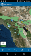
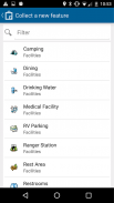
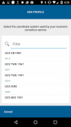
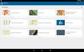
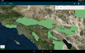
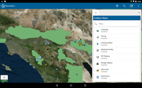
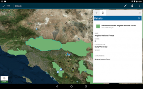
The app provides the capability to collect various types of data, including points, lines, and areas, along with related information. This flexibility enables users to perform diverse tasks, from mapping infrastructure to surveying natural resources. By utilizing easy-to-use, map-driven forms, users can streamline the data entry process, ensuring that information is recorded accurately and efficiently in the field.
Working offline is a significant advantage of Collector for ArcGIS. Users can download maps to their devices, allowing them to continue their work even in areas with limited or no internet connectivity. This feature is particularly useful for field workers who may operate in remote locations where data access is unreliable. Once connectivity is restored, users can sync their collected data with the central GIS database.
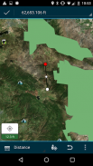
In addition to basic data collection, the app supports the attachment of photos to features. This capability allows users to provide visual context to their data, enriching the information captured. For instance, when surveying a site, a user can take photographs of specific locations and link them directly to their corresponding data points. This feature enhances the overall data quality and aids in better decision-making.
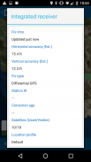
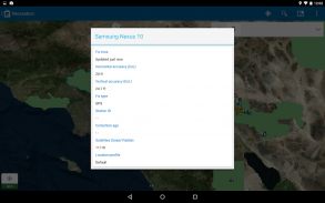
Collector for ArcGIS also integrates with professional-grade GPS receivers, offering precise location tracking. This integration ensures that the collected data is accurate and reliable, which is essential for detailed mapping projects. Users can rely on this feature to obtain high-quality spatial data, which is crucial for various applications, including urban planning and environmental monitoring.
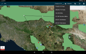
Another aspect of the app is its search functionality. Users can easily search for places and features, facilitating quick navigation and data retrieval. This capability is beneficial when working with extensive datasets or when users need to locate specific points of interest rapidly.
Tracking and reporting location history is another feature that enhances the app's usability. Users can monitor their movements and generate reports based on their collected data. This feature is helpful for organizations that require accountability and transparency in their fieldwork.
Collector for ArcGIS promotes integration with other applications within the ArcGIS suite, such as Navigator for ArcGIS and Workforce for ArcGIS. This interoperability allows users to leverage multiple tools for enhanced project management and data analysis. By connecting with these applications, users can optimize their workflows and improve their overall efficiency in the field.
The user interface of Collector for ArcGIS is designed for ease of use, accommodating both inexperienced and skilled users. The intuitive layout enables quick access to essential tools and features, which is particularly beneficial in fast-paced field environments. Users can navigate through the app with minimal training, allowing them to focus on data collection rather than becoming bogged down by technical difficulties.
Collaboration is another important aspect of Collector for ArcGIS. The app enables teams to share collected data in real-time, fostering cooperation among team members and improving project outcomes. By sharing insights and findings instantly, users can make informed decisions collectively, which is particularly advantageous in large-scale projects.
Mobile data collection is increasingly vital in various sectors, including environmental science, urban development, and public health. Collector for ArcGIS addresses this need by providing a robust platform for field data collection and management. Its comprehensive features support users in their efforts to gather and utilize spatial data effectively.
With its focus on flexibility and ease of use, Collector for ArcGIS has become a valuable tool for professionals in multiple fields. The ability to collect, update, and manage geographic data directly from a mobile device enhances operational efficiency and data accuracy. Organizations can significantly benefit from the app's capabilities, making it an essential resource for modern data collection practices.
Users seeking to enhance their field data collection processes will find that Collector for ArcGIS meets a wide range of needs. The combination of offline capabilities, accurate GPS integration, and user-friendly design makes it a practical choice for anyone involved in GIS work. By utilizing this app, professionals can ensure that their data collection efforts are both efficient and reliable.
The app stands out as a key player in the realm of mobile GIS tools, providing essential features that support effective data management and collaboration. With the ongoing development of technology and the increasing demand for accurate geographic information, Collector for ArcGIS remains a relevant and effective solution for various industries.
Collector for ArcGIS - Version 18.0.3
(02-03-2020)
Collector for ArcGIS - APK Information
APK Version: 18.0.3Package: com.esri.arcgis.collectorLatest Version of Collector for ArcGIS
Other versions


Apps in the same category

You may also like...


